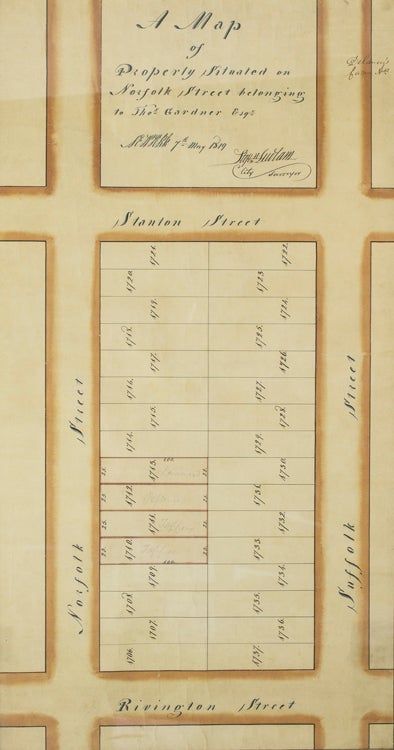

Manuscript Map of a Block in Old New York, 1819
Manuscript map of “Property Situated on Norfolk Street belonging to Thos. Gardner, Esq.” signed by Stephen Ludlam, City Surveyor, pen, ink and colors on paper.
New York: May 7, 1819.
Price: $750.00
About the item
1 vols. Image 23 x 12 inches, framed. Manuscript Map of a Block in Old New York, 1819. Fine. NYC/filed trip.
Item #27049
Mr. Gardner's block, on Manhatten's Lower East Side, is bounded by Norfolk, Stanton, Suffolk and Rivington Streets, and consists of 32 numbered parcels of surveyed land, 16 fronting on Norfolk Street and 16 on Suffolk Street, each 25 feet wide and 100 feet deep. Four Norfolk Street parcels are tinted, evidently to indicate leases, as pencilled on these are the names Lawrence, Pessenger, and Tappen (2 parcels). (There were several prominent Tappens in New York at this time, and doubtless some obscure ones; we have not been able to determine which Tappen this might have been). Off Suffolk Street, diagonally across from Gardner's block, the words “Delancy's Farm” have been inked in, another familiar New York name, surviving in today's Delancy Street. An historic and interesting glimpse of Old New York.